Drilling firm Lapindo Brantas has denied that one of its gas exploration well was the trigger for the Lusi mud volcano, which killed 13 people and displaced thirty thousand in East Java, Indonesia on May 29, 2006. The firm instead blamed an earthquake that occurred 280 kilometers (174 miles) away and backed up their claims in an article published in Marine and Petroleum Geology.
In response, a group of scientists from the United Kingdom, United States, Australia and Indonesia have written a discussion paper in which they claim to refute the main arguments made by Lapindo Brantas and document…
Geology

Depicting a cause-and-effect scenario that spans thousands of miles, scientists report in Geophysical Research Letters that ocean waves originating along the Pacific coasts of North and South America could play a role in the catastrophic collapse of Antarctic ice shelves.
Storm-driven ocean swells travel across the Pacific Ocean and break along the coastlines of North and South America, where they are transformed into very long-period ocean waves called "infragravity waves." The transformed waves then travel vast distances to Antarctica.
The Authors of the study propose that the southbound…

Writing in the journal Radiocarbon, researchers report the development of a new calibration curve that could answer key questions about human evolution and climate change. The new calibration curve, which extends back 50,000 years, is a major landmark in radiocarbon dating-- the method used by archaeologists and geoscientists to establish the age of carbon-based materials.
The curve, called INTCAL09, not only extends radiocarbon calibration but also considerably improves earlier parts of the curve.
"The new radiocarbon calibration curve will be used worldwide by archaeologists and earth…
University of Miami geologists have analyzed images based on Synthetic Aperture Radar (SAR) observations taken before and after Haiti's devastating January 12 earthquake. The images reveal surprising new details that may help the island better mitigate future earthquakes.
According to the new data, the earthquake rupture did not reach the surface--unusual for an earthquake this size. More importantly, the images confirm that only the western half of the fault segment that last ruptured in 1751 actually ruptured in the current earthquake.
"We're still waiting for the other shoe to drop…

When we experience disasters like the earthquake in Haiti January 2010, we naturally ask the questions: Could we have known (early warning)? Could we have been prepared (mitigation plans)?
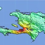
Haiti on the Hispaniola island in the Caribbean. Credit: USGS
There is no simple answer to that, because it relies on many factors. Technically, Haiti could have been better prepared, in the sense that we have the knowledge to build early warning systems and disaster mitigation plans. In the case of Haiti, scientists knew since 1998 (Timothy Dixon et al) that stress was building up fast and ready to…

When we experience disasters like the earthquake in Haiti January 2010, we naturally ask the questions: Could we have known (early warning)? Could we have been prepared (mitigation plans)?
Haiti on the Hispaniola island in the Caribbean. Credit: USGS
There is no simple answer to that, because it relies on many factors. Technically, Haiti could have been better prepared, in the sense that we have the knowledge to build early warning systems and disaster mitigation plans. In the case of Haiti, scientists knew since 1998 (Timothy Dixon et al) that stress was building up fast and…

The Haiti Earthquake: Science, Early
warning and mitigation
When we experience disasters like the earthquake in Haiti February
2010, we naturally ask the questions: Could we have known (early
warning)? Could we have been prepared (mitigation plans)?
There is no simple answer to that, because it relies on many
factors. Technically, Haiti could have been better prepared, in the
sense that we have the knowledge to build early warning systems and
disaster mitigation plans. In the case of Haiti, scientists knew
since 1998 (Timothy Dixon et al) that stress was building up fast and
ready to cause…

Researchers analyzing recent data from the SPOT 5 and ASTER satellites say that previous studies have largely overestimated mass loss from Alaskan glaciers over the past 40 years. Writing in a recent issue of Nature Geoscience, the team suggests that mass loss in these glaciers contributed 0.12 mm/year to sea-level rise between 1962 and 2006, rather than 0.17 mm/year as previously estimated.
The new estimate was obtained by comparing recent topographies, derived from Spot 5-HRS (SPIRIT project with maps from the 1950-60s, which enabled loss from three quarters of the Alaskan glaciers to be…

Haiti Event Supersite Established
The Group on Earth Observations (GEO) has set up a website page bringing together a welter of geological facts about the recent earthquake in Haiti, together with many web links.
The site will be of great benefit to geologists and students of geology.
http://supersites.unavco.org/haiti.php

Post Glacial Eustatic Sea Level Rise
Was The Danube The Location Of The Noah's Ark Flood? asks a scientificblogging.com news item.
Was it the location of Noah's flood? Doubtful, but it was the location of a flood, just one of many from human prehistory.
Post Glacial Eustatic Sea Level Rise happened across the globe: as implied by the term 'eustatic'. Eustatic sea level rise doesn't ask about people's ethnic, religious or geopolitical divisions. Nor does it inquire into whether humans are hunters, gatherers, farmers or manufacturers. In cases of catastrophic sea…