Geology

Scientists using NASA satellites have discovered an extensive network of waterways beneath a fast-moving Antarctic ice stream that provide clues as to how "leaks" in the system impact sea level and the world's largest ice sheet. Antarctica holds about 90 percent of the world's ice and 70 percent of the world's reservoir of fresh water.
With data from NASA satellites, a team of scientists led by research geophysicist Helen Fricker of the Scripps Institution of Oceanography, La Jolla, Calif., detected for the first time the subtle rise and fall of the surface of fast-moving ice streams as the…

When glaciologist Lonnie Thompson returns to Peru's Qori Kalis glacier early this summer, he expects to find that half of the ice he saw during his visit there last year has vanished.
What troubles him the most is his recent observations that suggest that the entire glacier may likely be gone within the next five years, providing possibly the clearest evidence so far of global climate change.
The fact that the Qori Kalis glacier, high in the Andes Mountains , is only one of many ice tongues retreating on the Quelccaya Ice Cap, the largest body of ice in the tropics, provides strong…

VK Raina, leading glaciologist and former ADG of the Geological Society of India, told the Hindustan Times that out of 9,575 glaciers in India, till date, research has been conducted only on about 50. Nearly 200 years data has shown that nothing abnormal has occurred in any of these glaciers.
It is simple. The issue of glacial retreat is being sensationalised by a few individuals, the septuagenarian Raina claimed. Throwing a gauntlet to the alarmist, he said the issue should be debated threadbare before drawing a conclusion.
However, Dr RK Pachouri, Chairman, Inter-Governmental Panel of…

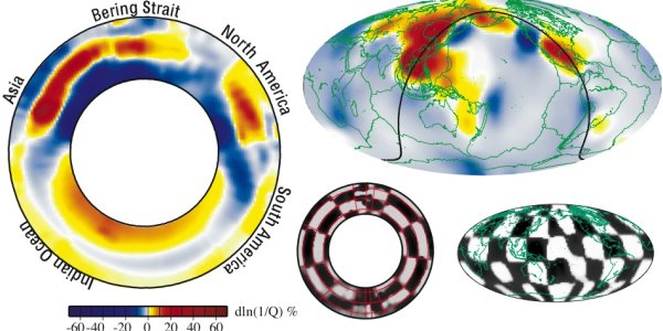
A seismologist at Washington University in St. Louis has made the first 3-D model of seismic wave damping — diminishing — deep in the Earth's mantle and has revealed the existence of an underground water reservoir at least the volume of the Arctic Ocean.
It is the first evidence for water existing in the Earth's deep mantle.
One of the most dramatic features in the Wysession et. al global mantle shear-wave attenuation model is a very high-attenuation anomaly at the top of the lower mantle beneath eastern Asia. This anomaly is believed due to water that has been pumped into the lower mantle…

New research findings may help refine the accepted models used by earth scientists over the past 30 years to describe the ways in which continents clash to form the Earth's landscape.
Eric Calais, an associate professor of geophysics at Purdue University, in collaboration with Ming Wang and Zenghang Shen from the Institute for Geology and Earthquake Science in China, used global positioning systems to record the precise movements of hundreds of points on the continent of Asia over a 10-year period.
Eric Calais, a Purdue associate professor of geophysics, shows equipment he used to track…

A greenhouse gas that has become the bane of modern society may have saved Earth from completely freezing over early in the planet's history, according to the first detailed laboratory analysis of the world's oldest sedimentary rocks.
Scientists have for years theorized that high concentrations of greenhouse gases could have helped Earth avoid global freezing in its youth by allowing the atmosphere to retain more heat than it lost. A team at the University of Chicago and the University of Colorado has now analyzed ancient rocks from the eastern shore of Hudson Bay in northern Quebec, Canada,…

Africa is being torn apart. And as Ethiopia's rift valley grows slowly wider, an international team of scientists is taking a unique opportunity to plot the progress of continents on the move.
The 28-strong team is led by University of Leeds geophysicist Dr Tim Wright, who has secured a £2.5 million grant from the Natural Environment Research Council (NERC) to study the seismic events taking place in the remote Afar desert of Northern Ethiopia.
It's here that two mighty shelves of continental crust, the African and Arabian plates, meet -- and are tearing the landscape apart.
3D view of…
The first scientific report into the causes and impact of Lusi, the Indonesian mud volcano, reveals that the 2006 eruption will continue to erupt and spew out between 7,000 and 150,000 cubic metres of mud a day for months, if not years to come, leaving at least 10 km2 around the volcano vent uninhabitable for years and over 11,000 people permanently displaced.
The paper by a Durham University-led team and published in the February issue of GSA Today1, reveals that the eruption was almost certainly manmade and caused by the drilling of a nearby exploratory borehole2 looking for gas,…

ESA's Mars Express has obtained images of the Cydonia region, site of the famous 'Face on Mars.' The High Resolution Stereo Camera photos include some of the most spectacular views of the Red Planet ever.
After multiple attempts to image the Cydonia region from April 2004 until July 2006 were frustrated by altitude and atmospheric dust and haze, the High Resolution Stereo Camera (HRSC) on board Mars Express finally obtained, on 22 July, a series of images that show the famous 'face' on Mars in unprecedented detail.
The data were gathered during orbit 3253 over the Cydonia region, with a…

These images, taken by the High Resolution Stereo Camera (HRSC) on board ESA's Mars Express spacecraft, show the Galle Crater, an impact crater located on the eastern rim of the Argyre Planitia impact basin on Mars.
The HRSC obtained these images during orbits 445, 2383, 2438, 2460 and 2493 with a ground resolution ranging between 10-20 metres per pixel, depending on location within the image strip.
The images show Crater Galle lying to the east of the Argyre Planitia impact basin and south west of the Wirtz and Helmholtz craters, at 51° South and 329° East.
The images of the 230 km diameter…