Geology

Article teaser image
Humans have yet to see Earth's center, as did the characters in Jules Verne's science fiction classic, "Journey to the Center of the Earth." But a new NASA study proposes a novel technique to pinpoint more precisely the location of Earth's center of mass and how it moves through space. Knowing the location of the center of mass, determined using measurements from sites on Earth's surface, is important because it provides the reference frame through which scientists determine the relative motions of positions on Earth's surface, in its atmosphere and in space. This information is vital to the…
Article teaser image
Some call it the eighth wonder of world. Others say it's the next Great Wall of China. Upon completion in 2009, the Three Gorges Dam along China’s Yangtze River will be the world's largest hydroelectric power generator and one of the few man-made structures so enormous that it's actually visible to the naked eye from space. NASA's Landsat satellites have provided detailed, vivid views of the dam since construction began in 1994. The Yangtze River is the third largest river in the world, stretching more than 3,900 miles across China before reaching its mouth near Shanghai. Historically, the…
Article teaser image
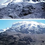
The "snows" of Africa's Mount Kilimanjaro inspired the title of an iconic American short story, but now its dwindling icecap is being cited as proof for human-induced global warming. However, two researchers writing in the July-August edition of American Scientist magazine say global warming has nothing to do with the decline of Kilimanjaro's ice, and using the mountain in northern Tanzania as a "poster child" for climate change is simply inaccurate. CLICK ABOVE FOR FULL SIZE.A photograph by Edward Oehler taken in 1912 (top) shows the extent of the icecap atop Mount Kilimanjaro, and a…
Article teaser image
Researchers have uncovered a large area of low but increasing gravity over North America – the lingering effect of the last ice age when sheets of ice sometimes three kilometres thick covered nearly all of Canada and the northeastern U.S. The study is the first to show a map of ongoing changes in the gravity field over North America due to the ice age. It provides an unprecedented image of the geometry of the long-vanished Laurentide ice sheet: a massive ice complex that had two major domes, one east and the other west of the Hudson Bay area, and raised global sea-level about 60 metres when…
Article teaser image
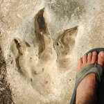
Dinosaur tracks, once neglected, are now considered a key source of scientific information on dinosaur behavior and ecology. A new study appearing in the May issue of The Journal of Geology provides fascinating insight into the factors geologists must account for when examining dinosaur tracks. The authors studied a range of larger tracks from the family of dinosaurs that includes the T. Rex and the tridactyl, and provide a guide for interpreting the effects of many different types of erosion on these invaluable impressions. Theropod dinosaur track from central Texas Edwards formation, Lower…
Article teaser image
A team of scientists announced today confirmation of a link between massive volcanic eruptions along the east coast of Greenland and in the western British Isles about 55 million years ago and a period of global warming that raised sea surface temperatures by five degrees (Celsius) in the tropics and more than six degrees in the Arctic. The study is important, experts say, because it documents the Earth’s response to the release of large amounts of greenhouse gases – carbon dioxide and methane – into the atmosphere, and definitively links a major volcanic event with a period of global…
Article teaser image
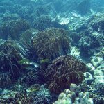
Scientists have reported what is thought to be one of the world’s greatest mass death of corals ever recorded as a result of the earthquake in Aceh, Indonesia on 28 March 2005. The recent survey by scientists from the Wildlife Conservation Society - Indonesia Program and the Australian Research Council Centre of Excellence for Coral Reef Studies (ARCCoERS) investigated the condition of coral reefs in Pulau Simeulue and Pulau Banyak off Aceh, Indonesia, in March 2007. CLICK IMAGE FOR FULL SIZE.Intact stands of Heliopora Pulau Banyak. Credit: Wildlife Conservation Society The surveys…
Article teaser image
Researchers from the Boston University Center for Remote Sensing used recently acquired topographic data from satellites to reveal an ancient mega-lake in the Darfur province of northwestern Sudan. Drs. Eman Ghoneim and Farouk El-Baz made the finding while investigating Landsat images and Radarsat data. Radar waves are able to penetrate the fine-grained sand cover in the hot and dry eastern Sahara to reveal buried features. Northern Darfur Mega-Lake. Credit: Boston University Center for Remote Sensing Segments of the lake's shoreline were identified at the constant altitude of 573 ± 3…
Article teaser image
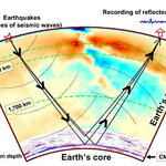
High-resolution images that reveal unexpected details of the Earth's internal structure are among the results reported by MIT and Purdue scientists in the March 30 issue of Science. The researchers adapted technology developed for near-surface exploration of reservoirs of oil and gas to image the core-mantle boundary some 2,900 kilometers, or 1,800 miles, beneath Central and North America. Seismic waves from earthquakes penetrate the Earth's mantle and scatter back at the core-mantle boundary to detectors on the surface. Nearly 100,000 such recordings are used to illuminate the planet's…
Article teaser image
The maximum extent of Arctic sea ice in winter 2007 was the second lowest on satellite record, narrowly missing the 2006 record, according to a team of University of Colorado at Boulder researchers. The Arctic sea-ice extent, which is the area of ocean covered by at least 15 percent ice, was 5.7 million square miles in March 2007, slightly higher than the record low of 5.6 million square miles measured in March 2006. The declining sea ice has been blamed on higher winter temperatures in the Arctic, a result of rising greenhouse gases in the atmosphere and strong natural variability in the…