Some of the coldest air of the 2014-2015 winter season is settling over the eastern two-thirds of the U.S., an Arctic air mass that brought wind chills from below zero to the single numbers from the Midwest to the Mid-Atlantic.
It is certainly cold on the surface, but infrared NASA satellite imagery revealed even colder temperatures in cloud tops associated with the air mass.
NOAA's GOES-East satellite provided a visible and infrared picture of the clouds associated with the Arctic air mass, as they stretched from the eastern Dakotas to the Mid-Atlantic region. Underneath that cloudy blanket, surface temperatures were far from warm. NOAA's National Weather Service noted on Feb. 13, "Dangerous wind chills will affect areas from the mid-Atlantic to New England on Friday as some of the coldest air of the season combines with gusty winds. Wind Chill Advisories, Watches and Warnings are in effect across the region."
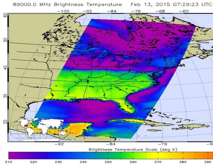
This false-colored infrared image from the AIRS instrument aboard NASA's Aqua satellite at 7:29 UTC (2:29 a.m. EST) shows cloud top temperatures over New York, Vermont, and New Hampshire near 245K/-28C/-18F (greenish to blue shading). Credit: Credit: NASA JPL, Ed Olsen
The Atmospheric Infrared Sounder (AIRS) instrument that flies aboard NASA's Aqua satellite gathered infrared data on the high, cold cloud tops associated with the pool of cold Arctic air now sitting over the northeastern U.S. The AIRS data were made into a false-colored infrared image at NASA's Jet Propulsion Laboratory, Pasadena, California. AIRS data revealed that cloud top temperatures over New York, Vermont, and New Hampshire (with a greenish to blue shading in the image) showed temperatures about 245K/-28C/-18F. Cloud top temperatures over southern Pennsylvania were near 250K/-23C/-9F.
Meanwhile, on the ground in New York City at 2 p.m. EST, Feb. 13, the air temperature was 19F/-7C, and the wind chill was 9F/-13C. In Burlington, Vermont on the ground, the temperature was 4F/-16C, and the wind chill was -8F/-22C and in Philadelphia, Pennsylvania the surface temperature was 23F/-5C with a wind chill near 9F/-13C.
So, although it's brutally cold on the surface, it's even colder in the clouds. Further, the data on those cloud temperatures does not include a wind chill!