Geology

Article teaser image
From the beginning of time, uranium has been part of the Earth and, thanks to its long-lived radioactivity, it has proven ideal to date geological processes and figuring out Earth’s evolution.  Natural uranium consists of two long-lived isotopes uranium-238 and the lighter uranium-235 and  uranium isotopes leave a distinct ‘fingerprint’ in the sources of volcanic rocks, making it possible to gauge their age and origin.    From early Earth history, the continental crust (the Earth’s thick solid outer skin that we live on) has accumulated mass from the underlying hot mantle…
Article teaser image
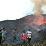
 On November 23rd, 2014, a new volcano eruption commenced on Fogo, one of the Cape Verde Islands, and it continues even now, making it the largest and most damaging eruption - and the biggest natural disaster no one in the western world was reading about it - on the archipelago for over 60 years.  Most of the damage was caused by lava flows advancing into populated regions and numerous buildings, homes and roads were destroyed. In total, three villages have been abandoned and thousands of residents were evacuated. Joao Relvas/EPA A team from the GFZ German Research Centre for…
Article teaser image
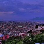
If Campi Flegrei ever goes off, you won't want to be in Naples - or Europe, for that matter. Emanuele Nicastro, CC BY-SA By Luca de Siena, University of Aberdeen Ever heard of Campi Flegrei? It is a supervolcano in southern Italy. Literally translating as “fields of fire,” only the Yellowstone caldera in the United States has more potential to devastate. The Naples urban area, with its four million inhabitants, extends within this amazing volcanic complex, though it lies mostly beneath the sea. The last time that Campi Flegrei erupted was less than 500 years ago, in 1538. It was one of the…
Article teaser image
Chemical analysis of some of the world’s oldest rocks has provided the earliest record yet of Earth's atmosphere and shows that the air 4 billion years ago was very similar a billion years later, when the atmosphere, though it likely would have been lethal to oxygen-dependent humans, supported a thriving microbial biosphere that ultimately gave rise to the diversity of life on Earth today. Until now, researchers have had to rely on widely varying computer models of the earliest atmosphere's characteristics. The new study builds on previous work by Jonathan O’Neil, an assistant professor at…
Article teaser image
The number of large earthquakes fell considerably in 2014, down to 12 from 19 in 2013. The trend was similar worldwide. Only 11 earthquakes reached magnitude 7.0-7.9 and one registered magnitude 8.2, in Iquique, Chile on April 1st. That was the lowest annual total of earthquakes magnitude 7.0 or greater since 2008, which also had 12. On average, since 1900 there have been 18 large earthquakes each year. Millions of earthquakes occur throughout the world each year but most go undetected because they have very small magnitudes or hit remote areas.  In the United States, the US…
Article teaser image
If you hit the ground with a hammer, it creates a micro-earthquake, but it is obviously too small to be detected. The ancient Chinese used to use a drum in the ground to listen for enemy sappers mining underneath their fortifications. The process of hydraulic fracturing, or fracking, extracts gas and oil from shale rock by injecting a high-pressure water mixture directed at the rock to release the oil and gas trapped inside. Like any geological event, that results in micro-earthquakes much smaller than humans can feel.  But in March 2014, a series of five recorded earthquakes in Poland…
Article teaser image
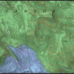
In December 2014, the U.S. Geological Survey (USGS) released its highest-resolution geologic map of Mars. The new geologic and structural map uses the highest-resolution, orbiter-based images currently available for Mars – data from the High Resolution Imaging Science Experiment (HiRISE) camera on board NASA’s Mars Reconnaissance Orbiter (MRO) – to illuminate past geological processes in a portion of “Grand Canyon of Mars” - Valles Marineris. The area analyzed, called western Candor Chasma, is one of the largest canyons in the Valles Marineris canyon system. In an interview with me, USGS…
Article teaser image
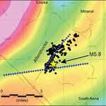
The 2011 east coast earthquake felt by people from Georgia to Canada likely originated from a fault “junction” just outside of Mineral, Virginia, according to new U.S. Geological Survey research published in the Geological Society of America’s Special Papers. Following the August 23, 2011 event, USGS scientists conducted low-altitude geophysical (gravity and magnetic) flight surveys in 2012 over the epicenter, located about eight miles from the quake’s namesake. Maps of the earth’s magnetic field and gravitational pull show subtle variations that reflect the physical properties of deeply…
Article teaser image
When the Bárðarbunga volcano beneath Iceland's Vatnajökull ice cap reawakened in August 2014, scientists got an opportunity to monitor how the magma flowed through cracks in the rock away from the volcano.  Although it has a long history of eruptions, Bárðarbunga has been increasingly restless since 2005, including a dynamic period in August and September of this year, when more than 22,000 earthquakes were recorded in or around the volcano in just four weeks, due to stress being released as magma forced its way through the rock.  The molten rock formed vertical sheet-like…
Article teaser image
Many villagers near the Cape Verde volcano will have little to return to. Joao Relvas/EPA By David Rothery, The Open University Around 60 volcanoes erupt in the average year. On any particular day, there are usually about 20 volcanoes erupting somewhere in the world. Naturally, they can’t all make headlines. But when there are human tragedies involved, we need to question the priorities of the news media. Contrast the fuss about eruption warnings in Iceland with the vanishingly low media profile of the current eruption on Fogo, one of the islands in the Cape Verde archipelago off the coast of…