Geology

Article teaser image
A photo from France today, the penultimate day of Evelyn's photo a day week. I apologise if this is a little late, I am writing this from the first train of my 13 hour epic journey home for Christmas, and I am somewhat lacking in internet. At least this year there is little snow to cause “travel chaos”... This picture comes from the Aven d'Orgnac, a cave in the Ardèche region of south west France. The formation you see is know as l'escargot, as it resembles a snail (being ridden by a dwarf). It is a stalagmite (albeit a rather wonderfully shaped stalagmite), formed by the action of water as…
Article teaser image
I'm getting my geophoto today in early, as it is the lab's Christmas party tonight... Today's photo is of Iguazú Falls, which straddle the Argentina/Brazil border (spelt Iguaçu on the Brazilian side). I posted this picture mainly because it is pretty, and waterfalls are geological, right?  But if you do want some geology, the rocks that you can just about make out behind all the water and vegetation are basalts, and a particular type of formation known as a flood basalt.  Flood basalts represent periods of intense volcanism, and are sometimes thought to lead to mass-extinction…
Article teaser image
For Thursday's contribution to Evelyn's photo meme, I present the Isle of Skye. Skye was perhaps my favourite field trip of my undergrad.  We stayed in cabins out in the middle of nowhere, by the sea, and by that time we had really got to know each other as a group.  We were practising our mapping on the area the cabins were sat, so every morning we literally just had to step out of the front door to be 'in the field'.  Because there weren't a set number of outcrops we had to see each day (we just wandered around, and every now and then a demonstrator would pop up from behind a…
Article teaser image
Day three of Evelyn's geophoto a day, and today we are in Greece. This photo was taken early one winters day as we were preparing to head out into the field.  At first glance, the geology in this picture is not obvious, unless you know a little of the geology of mainland Greece.  Greece is being stretched, and this leads to a series of normal faults.  One side of these faults is raised up, the other drops down.  The Gulf of Evia, pictured below, was formed by one of these faults.  It is still growing today, slowly. In the photo below, you can actually see the fault.…
Article teaser image
Day two of Evelyn Mervine's photo meme, and today I have a picture of Ngauruhoe, New Zealand.  Ngauruhoe makes almost a perfect cone, broken only at the top by a small crater.  This photo was taken from the summit, looking north.  A small amount of steam can be seen rising from Ngauruhoe itself, showing this volcano is far from dead.  Further in the background is part of Tongariro, the larger volcanic complex that Ngauruhoe is just one vent of.  In the distance is lake Taupo, which is itself a large, volcanic caldera.  All in all, this shows how the Taupo…
Article teaser image
Like Evelyn Mervine over at the Georneys blog, I have been neglecting this blog a little this past week (although I don't have as good an excuse as she does, I was just having fun...).  I do like the idea of posting a geology photo each day this week, so I have accepted her invitation to join her. For the first photo, I have these ripple marks.  They are in some Triassic sandstone, found in an abandoned quarry.  A lot of geology is done in abandoned quarries.  I hadn't quite expected to get up where I did.  I was following a cutting alongside an overgrown track, and…
Article teaser image
I've been a great admirer of GRACE since the first time I 'met her'. That was at a meeting in Potsdam, Germany, a beautiful city just outside (on the 'wrong side' = old Eastern Germany) Berlin. I was attending a geodesy meeting, I do not even remember exactly which one,  when we popped in to listen to Chris Reigber, one of the pioneers in space-based gravity measurements, giving a talk thanking the community for a reward he had just gotten for his work in this field. GRACE is the brainchild of Chris Reigber and his group at Geoforschungzentrum in Potsdam, and NASA. One of the remarkable…
Article teaser image
Earth Science Bonanza is the best way of describing a meeting where 20 000 Earth science scientists gather from around the entire world. For a whole week San Francisco is saturated with scientists. The highest density can be found around Union Square more specifically at Moscone center. The yearly AGU Fall meeting has started.... I've been here numerous times and this year I have two oral presentations. One of which is a spin-off from an article I wrote here on Science 2.0 in the wake of the Eyjafallajökull volcanic ash cloud that caused major havoc in April 2010. I've registered my blog on…
Article teaser image
In this post, I want to set off on a voyage, a voyage to visit some of the less well-known volcanoes of the world.  I'll take a look as some volcanoes you may not of heard of, and it will also be a bit of a learning experience for me as I read a bit more about these places.  These sort of things usually need a gimmick, so I thought I'd go with an old-fashioned a-to-z.  As is customary, I start with an A: Aniakchak. Vent Mountain, the largest cone inside the caldera of Aniakchak.  Photo CC BY-NC-SA by Buzz Hoffman.Aniakchak is located in Alaska, and is part of the Pacific '…
Article teaser image
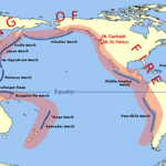
Extreme Geohazards – what are they?In December 2004, we all learned one Japanese word; tsunami  (津波, lit. "harbor wave"). Japan has seen a number of tsunamis through out times, situated right there on the Ring of Fire, and when the Sumatran earthquake hit the ocean floor in the Indian ocean in 2004 creating the monster waves killing some 300 000 people, tsunami became a household Japanese word, included in many languages. The Ring of Fire is an area where large numbers of earthquakes and volcanic eruptions occur in the basin of the Pacific Ocean. I visited Japan for the first time in…