On May 27th, 2006 the ground on Java, an Indonesian island, shook with a magnitude 6.3 earthquake. The epicenter was located 25 km southwest of the city of Yogyakarta and initiated at a depth of 12 km.
The earthquake took thousands of lives, injured ten thousand more and destroyed buildings and homes. 47 hours later, about 250 km from the earthquake hypocenter, a mud volcano formed that came to be known as "Lusi", short for "Lumpur Sidoarjo".
Hot mud erupted in the vicinity of an oil drilling-well, shooting mud up to 50 m into the sky and flooding the area. It continues to erupt today…
Geology

The largest known submarine landslide has been identified in the Gulf of Mexico, generated by the Chicxulub extraterrestrial impact which also caused the mass-extinction at the end of the Cretaceous period, providing new evidence for widespread Chicxulub-induced slope failure.
The landslide, the single largest-known mass wasting deposit, was triggered when seismic shock waves and tsunamis caused sediments on the Gulf of Mexico sea floor deposited during the prior 10 million years to be eroded and lifted up into the water column.
These sediments then settled back down onto the seafloor…

Rapid coastal subsidence in the central Ganges-Brahmaputra Delta (Bangladesh) since the 17th century has been deduced from submerged salt-producing kilns.
The densely populated low-lying Ganges-Brahmaputra Delta is highly vulnerable to the global sea-level rise. In order to estimate the subsidence of the delta over historical time scales, as a complement to existing entire-Holocene or modern data, we examined submerged salt-producing kiln sites in the coastal Sundarbans.
These kilns were built just above the previous winterly spring high-tide level, but are currently located ~155 (plus or…

The water level in the Dead Sea has been dropping at an increasing rate since the 1960s, exceeding a meter per year during the past decade. This drop has triggered the formation of sinkholes and widespread land subsidence along the Dead Sea shoreline, resulting in severe economic loss and infrastructural damage.
In a new paper, researchers examined the spatiotemporal evolution of sinkhole-related subsidence using Satellite based Interferometric synthetic aperture radar (InSAR) measurements and field surveys, and resolved millimeteric-scale precursory subsidence in all sinkhole sites that…

The Earth has a violent history: About 4.5 billion years ago, a maelstrom of gas and dust circled in a massive disc around the sun, gathering in rocky clumps to form asteroids. These asteroids, gaining momentum, whirled around a fledgling solar system, repeatedly smashing into each other to create larger bodies of rubble — the largest of which eventually cooled to form the planets.
Countless hypotheses, simulations and geologic observations support such a scenario, but there remains one lingering mystery: If the Earth arose from the collision of asteroids, its composition should resemble that…

Despite much research on the many processes that erode rocky coastal cliffs, accurately predicting the nature, location and timing of coastline retreat remains challenging. This is also confounded by the apparently episodic nature of cliff failure.
Coastline retreat via progressive failure of rocky coastal cliffs
The dominant drivers of coastal erosion, marine and sub-aerial processes, are anticipated in future to increase, so understanding their present and combined efficacy is fundamental to improving predictions of coastline retreat.
The researchers captured change using repeat…

Certain sections of strike-slip faults, known as restraining bends, are sites of unusual tectonic activity because they undergo more contractional motion than surrounding areas.
These bends can be the site of major contraction-dominated earthquakes that are difficult to characterize using traditional means. Over millions of years, these earthquakes build substantial mountain ranges, such as the site of the present study, the Santa Cruz Mountains, California.
This study tests a method for estimating where and how fast these tectonic motions build mountains based on rates of river erosion at…

Lake Qinghai is the largest interior plateau lake in North China and has long been sensitive to climate change and the environmental effects of Tibetan Plateau uplift.
Long, continuous, terrestrial lacustrine sedimentary records are extremely rare but an almost continuous 626 m long sediment core of
ancient Lake Qinghai
have been obtained from an in-filled part of the southern lake basin, which documents both the age of the origin of the lake and the evolution of the East Asian monsoon during the Late Cenozoic.
A new study presents a high-resolution magnetostratigraphy work which…

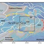
New geologic evidence that casts doubt on one of the conventional explanations for how Antarctica's ice sheet began forming, says a team of researchers writing in Geology.
The Antarctic Circumpolar Current (ACC), an ocean current flowing clockwise around the entire continent, insulates Antarctica from warmer ocean water to the north, helping maintain the ice sheet.
For several decades, scientists have surmised that the onset of a complete ACC played a critical role in the initial glaciation of the continent about 34 million years ago.
Now, rock samples from the central Scotia Sea near…

Geophysicists conducting an analysis of earthquakes in the area around the Salton Sea Geothermal Field in southern California found a strong correlation between seismic activity and operations for production of geothermal power, which involve pumping water into and out of an underground reservoir.
Emily Brodsky, a professor of Earth and planetary sciences at the University of California, Santa Cruz,and coauthor Lia Lajoie, who worked on the project as a UC Santa Cruz graduate student, studied earthquake records for the region from 1981 through 2012. They compared earthquake…