Geology

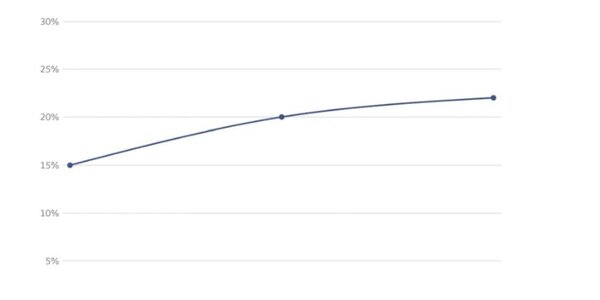
Since October 2013, the rate of earthquakes in Oklahoma has been up by about 50 percent, which has geologists thinking about the chance for a damaging quake in central Oklahoma.
A joint statement by the U.S. Geological Survey and Oklahoma Geological Survey says that 183 earthquakes of magnitude 3.0 or greater occurred in Oklahoma from October 2013 through April 14, 2014. The long-term average from 1978 to 2008 showed only two magnitude 3.0 or larger earthquakes per year. The increased number of small and moderate shocks has led them to predict a higher likelihood of future, damaging…

Can using a well move a mountain? It will if the well is big enough.
Winter rains and summer groundwater pumping in California's Central Valley make the Sierra Nevada and Coast Mountain Ranges sink and rise.
How much? A few millimeters each year. That doesn't sound like a lot but it creaes stress on the state's faults that could increase the risk of an earthquake.
Gradual depletion of the Central Valley aquifer due to groundwater pumping also raises these mountain ranges by a similar amount - about the thickness of a dime - each year, according to a new paper in Nature. That cumulative rise…

A new discovery in the study of how lava dome volcanoes erupt may help predict how a volcanic eruption will behave.
Volcanologists say a process called frictional melting plays a role in determining how a volcano will erupt, by dictating how fast magma can ascend to the surface, and how much resistance it faces en-route.
The process occurs in lava dome volcanoes when magma and rocks melt as they rub against each other due to intense heat. This creates a stop start movement in the magma as it makes its way towards the earth's surface. The magma sticks to the rock and stops moving until enough…

University of California, Berkeley, geologist William Dietrich pioneered the application of airborne LIDAR, light detection and ranging, to map mountainous terrain, stripping away the vegetation to see the underlying ground surface - but he still couldn't see what was under the surface: the depth of the soil, the underlying weathered rock and the deep bedrock.
He and geology graduate student Daniella Rempe have now proposed a method to determine these underground details without drilling, potentially providing a more precise way to predict water runoff, the moisture available to plants,…

The oldest sections of transform faults, such as the North Anatolian Fault Zone and the San Andreas Fault, produce the largest earthquakes, putting important limits on the potential seismic hazard for less mature parts of fault zones, according to a new presentation ("Fault-Zone Maturity Defines Maximum Earthquake Magnitude") at the Seismological Society of America 2014 Annual Meeting in Anchorage.
Identifying the likely maximum magnitude for the
North Anatolian Fault Zone
is critical for seismic hazard assessments, particularly given its proximity to Istanbul so the researchers…

When and where did the ancient Iapetus Ocean suture (the most fundamental Appalachian structure) form? Is part of New England made up of ancient African-derived rocks? What is the Moretown terrane?
Mountain-building events, called "orogenies," in the northern U.S. Appalachia record the closure of the Iapetus Ocean, an ancient precursor to the Atlantic. The Iapetus separated continental fragments of ancestral North America and Africa more than 450 million years ago.
The mountain-building period that affected most of modern-day New England, known as the "Taconic orogeny," is commonly…

Parts of the landscape underlying the massive Greenland ice sheet may have been undisturbed for almost 3 million years, since the island became completely ice-covered, say researchers who based their discovery on an analysis of the chemical composition of silts recovered from the bottom of an ice core more than 3,000 meters long.
The find suggests "pre-glacial landscapes can remain preserved for long periods under continental ice sheets."
In the time since the ice sheet formed "the soil has been preserved and only slowly eroded, implying that an ancient landscape underlies 3,000…

Geologists have analyzed 40 meteorites that fell to Earth from Mars those chemical signatures have revealed some secrets of the early Martian atmosphere.
The atmospheres of Mars and Earth diverged in important ways very early in the 4.6 billion year history of our solar system.
Of course, what everyone wants to know is if life ever existed there and how water flowed in the past. Those answers are still waiting to be found but researchers are learning where to look.
The researchers measured the sulfur composition of 40 Mars meteorites—a much larger number than in previous analyses. Of more…

The Tibetan Plateau — the world's largest, highest, and flattest plateau — had a larger initial extent than previously documented.
Known as the "Roof of the World," the Tibetan Plateau covers more than 970,000 square miles in Asia and India and reaches heights of over 15,000 feet. The plateau also contains a host of natural resources, including large mineral deposits and tens of thousands of glaciers, and is the headwaters of many major drainage basins.
Gregory Hoke, assistant professor of Earth sciences at Syracuse University, and Gregory Wissink, a Ph.D. student in his lab, have co…

The Moon formed nearly 100 million years after the start of the solar system, according to a paper based on measurements from the interior of the Earth combined with computer simulations of the protoplanetary disk from which the Earth and other terrestrial planets formed.
The team of researchers simulated the growth of the terrestrial planets (Mercury, Venus, Earth and Mars) from a disk of thousands of planetary building blocks orbiting the Sun.
By analyzing the growth history of the Earth-like planets from 259 simulations, the scientists discovered a relationship between the time the Earth…