Oceanography

Article teaser image
Across the North Atlantic, shipwrecks scatter the seabed like the carcasses of prehistoric creatures. Bygone relics of sea exploration, trade, migration and conflict, these historical monuments are important sites of cultural interest. But they also form the basis of a burgeoning recreational dive tourism industry, and contribute substantially to the biodiversity and abundance of marine life. The stories behind how these ships came to rest on the sea bed are intriguing. In the Orkney Isles off the north coast of Scotland, for example, a major naval event at the close of World War I set the…
Article teaser image
A new paper is proposing that methane due to lakes is scarier than carbon dioxide, but it tells only one sider of the story: methane has much greater warming impact, they rightly note, but leave out that it is so short-lived it is having zero impact on climate change. Marine environmental activists are leading the charge against methane, for reasons that are not yet clear: a marine biologist became famous for claiming natural gas was worse for the environment than CO2, and though his findings have long since been debunked, it continues to be a story for environmental fundraisers. Now a paper…
Article teaser image
Climate change is a hot-button topic that is sure to  spark arguments between those who believe the climate is changing and those who believe it’s not, or at least that if it is, it's due to natural processes. Researchers around the world are researching ways to address climate change, some well-known and some controversial . One controversial  idea states that seeding the ocean with dissolved iron could help stave off climate change. Is this a legitimate possibility, possibly more harm than good, or just a shot in the dark? The Theory of Geoengineering The concept of seeding the…
Article teaser image
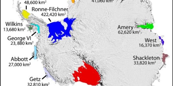
The Amery Zig-Zags Cracks in the Amery Ice Shelf show a prominent zig-zag form.  This is a type of crack which forms in a laminated material which is deformed under pressure.   As the laminate is forced into a curve it tends to crack in a series of radial and lateral failures. The Amery Ice Shelf is the largest of the East Antarctic ice shelves.  Its location is shown in the map below. Antarctica ice shelvesimage courtesy NSIDC. The image below, from aqua 2017 01 05, shows all of the major cracks. The false colour image below, enhanced from aqua 2017 01 21 shows the rifts…
Article teaser image
Something is wrong in the Arctic It has long been predicted that as the amount of CO2 in the atmosphere climbs, so too will the average global temperature, with the greatest temperature increases being seen at the poles.  This year, the polar amplification effect is in full swing, with exceptional global losses of sea ice. Sea ice hits record lowsAverage Arctic sea ice extent for November set a record low, reflecting unusually high air temperatures, winds from the south, and a warm ocean. Since October, Arctic ice extent has been more than two standard deviations lower than the long-term…
Article teaser image
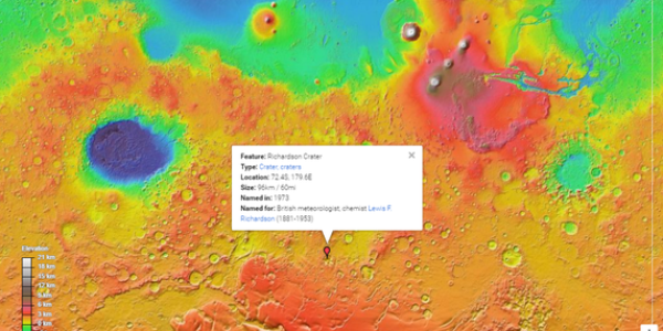
"What area on Mars is the most interesting for us?". My answer to this question isn’t an impressive geological feature like Olympus Mons or Valles Marineres. For me, it’s a rather unremarkable seeming crater, Richardson crater near the south pole. Let me explain why. First this shows where it is. It is close to the south pole - this is an elevation map and I’ve trimmed it down to the southern hemisphere. You can see Olympus Mons as the obvious large mountain just right of middle, and Hellas Basin as the big depression middle left. Richardson crater is about half way between them and much…
Article teaser image
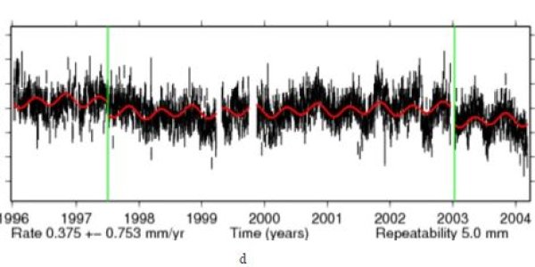
Postglacial rebound, uplift in Greenland blamed on global warming, has actually made it harder to measure ice loss due to global warming, according to a new paper in Science Advances. The Greenland Ice Sheet sits on the Earth’s solid crust, which is in turn perched atop a softer layer of rock called the mantle. When the ice sheet loses ice, the crust underneath rises up, similar to the way in which a compressed spring will bounce up when pressure is removed. This uplift, called postglacial rebound, means that scientists can’t measure how much an ice sheet is shrinking by simply tracking…
Article teaser image
Declining Antarctic sea ice extents were a cornerstone of climate models - unless they began increasing. It may be that both are just natural fluctuation according to a new paper which shows that the negative phase of the Interdecadal Pacific Oscillation (IPO), which is characterized by cooler-than-average sea surface temperatures in the tropical eastern Pacific, has created favorable conditions for additional Antarctic sea ice growth since 2000. Obviously that could mean that sea ice may begin to shrink as the IPO switches to a positive phase. Climate models have done a poor…
Article teaser image
The frequency of nuisance tidal flooding in many U.S. cities was predicted for the 2015 meteorological year, from May 2015 to April 2016, according to a new NOAA report. Sure, records can be broken, but the existing records broke an old one too. El Niño has been misused and abused in forecasts and projections for decades. Some of the really glaring errors in the early days of climate change data were made because scholars with scant knowledge of complex statistics didn't control for El Niño, and that causes a lot more havoc than nuisance flooding.  Nuisance flooding depends on…
Article teaser image
A new paper in American Journal of Geophysics, Geochemistry and Geosystems criticizes alarming projections of up to 2 meters in sea level rise due to increasing anthropogenic CO2 emissions - and implicitly media that acts as cheerleaders by foregoing critical thinking - because those claims are not based on data.  Instead of noting that tide gauges with enough information to infer a trend don't show increased relative rate of rise, but instead show small positive negative and positive fluctuations, papers with claims of up to 2 meters in sea level rise are heavily promoted, including by…