When NASA's Aqua satellite passed over Tropical Storm Arthur on July 2 at 2:50 PM EDT on July 2nd, it saw a cloud-covered eye as the storm was on the way to becoming a hurricane.
This visible image of Tropical Storm Arthur was captured by the Moderate Resolution Imaging Spectroradiometer or MODIS instrument that flies aboard NASA's Aqua satellite. Arthur's center was over the Atlantic Ocean and east of Florida's northeast coast.
By 5 AM EDT on July 3, Arthur's eye had formed but remained cloud covered even as the storm hit hurricane-strength with maximum sustained winds near 75 MPH.
The Atmospheric Infrared Sounder or AIRS instrument aboard NASA's Aqua satellite captured infrared data on Tropical Storm Arthur's cloud tops on July 3 at 2:47 PM EDT. The data was made into a false-colored infrared image at NASA's Jet Propulsion Laboratory in Pasadena, California. The image showed powerful thunderstorms around Arthur's center with temperatures near -63F/-53C.
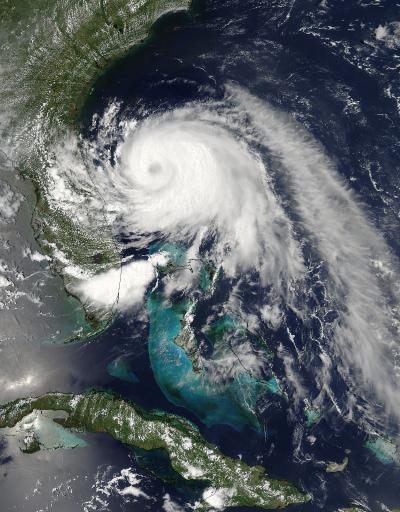
This visible image of Tropical Storm Arthur was taken by the MODIS instrument aboard NASA's Aqua satellite on July 2 at 18:50 UTC (2:50 p.m. EDT). A cloud-covered eye is clearly visible. Image: NASA Goddard MODIS Rapid Response Team
Cloud tops that cold tower to the near the top of the troposphere and have the ability to produce heavy rainfall.
By 8 AM EDT on July 3rd, watches and warnings peppered the U.S. Southeast. The National Hurricane Center or NHC issued the following: a hurricane warning is in effect for Surf City, North Carolina to the North Carolina/Virginia Border, Pamlico Sound and the Eastern Albemarle Sound. A hurricane watch is in effect for the Little River Inlet to south of Surf City.
In addition, a tropical storm warning is in effect for South Santee River, South Carolina to south of Surf City; the North Carolina/Virginia border to Cape Charles Light; and Virginia, including the mouth of the Chesapeake Bay; and the Western Albemarle Sound.
On July 3 at 8 AM EDT (1200 UTC) the center of Hurricane Arthur was near latitude 31.8 north and longitude 78.7 west. That puts Arthur's center about 300 miles (480 km) southwest of Cape Hatteras, North Carolina, and just 150 miles (240 km) south-southwest of Cape Fear, North Carolina. Maximum sustained winds have increased to near 80 mph (130 kph) and some additional strengthening is forecast during the next 24 hours.
The National Hurricane Center noted that Arthur is moving toward the north-northeast near 9 mph (15 kph and a turn to the northeast is expected. Arthur's center is expected to approach the coast in the hurricane warning area tonight, July 3.
Forecaster Brennan noted in the July 3 discussion on Arthur that after moving very close to the North Carolina Outer Banks late on July 3 and early July 4, the storm should then accelerate northeastward offshore of the mid-Atlantic states and the northeastern U.S. on July 4. By July 5, the NHC expects Arthur to move into the Canadian Maritimes.
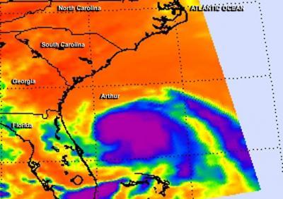
This false-colored infrared image from the AIRS instrument aboard NASA's Aqua satellite on July 3 at 2:47 p.m. EDT shows powerful thunderstorms (purple) around Arthur's center. The powerful, high cloud tops had temperatures near -63F/-53C. Image : NASA JPL/Ed Olsen