Typhoon Francisco was already spreading fringe clouds over southern Japan when NASA's Aqua satellite flew overhead and captured a picture of the storm from space on Oct. 22nd at 04:30 UTC/12:30 a.m. EDT.
Aqua captured Typhoon Francisco approaching Japan with a tightly wound center and small eye. Bands of thunderstorms wrapped into the center from the northern and southern quadrants of the storm as Francisco moved toward Japan. The image was created by the NASA MODIS Rapid Response Team at NASA's Goddard Space Flight Center in Greenbelt, Md.
On Oct. 22 at 1500 UTC/11 a.m. EDT, Typhoon Francisco had maximum sustained winds near 75 knots/86.1 mph/138.9 kph. It was centered about 350 nautical miles east-southeast of Kadena Air Base, Okinawa, Japan, near 23.2 north and 133.1 east. The strongest winds, typhoon-force extend 40 nautical miles/46 miles/74 km from the center, or 80 nautical miles/92 miles/148 km in diameter. Tropical-storm-force winds extend as far as 130 nautical miles/149.6 miles/ 240.8 km from the center, making the storm over 260 miles in diameter.
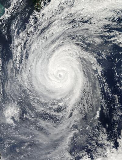
On Oct. 22nd at 04:30 UTC/12:30 a.m. EDT, NASA's Aqua satellite captured this stunning visible image of Typhoon Francisco approaching Japan (top left corner in the Pacific Ocean. Image : NASA Goddard MODIS Rapid Response Team
Francisco was moving to the northwest at 7 knots/8 mph/12.9 kph, but is expected to turn to the northeast in the next day or two. As Francisco heads toward Japan, the storm is stirring up very rough seas with wave heights topping 30 feet, according to the Joint Typhoon Warning Center. On Oct. 22, Japan's southern islands were all under advisory status for high waves and/or gale force winds.
Francisco continues to slowly weaken and is expected to become extra-tropical after passing southern Japan in the next couple of days.