NASA's Aqua satellite captured strong thunderstorms with colder cloud tops that have grown within Tropical Storm Rachel in the Eastern Pacific Ocean.
Aqua passed over the large Tropical Storm Rachel on Sept. 25 at 4:41 p.m. EDT and the Atmospheric Infrared Sounder or AIRS instrument, saw that the extent of colder cloud tops had increased, indicating thunderstorm heights were increasing and it was strengthening. The expansion of those stronger thunderstorms also suggests that the northeasterly wind shear may be relaxing a little. The strongest thunderstorms remain limited to the southwest of the low-level center,
At 5 a.m. EDT on Sept. 26, the center of Tropical Storm Rachel was located near latitude 18.0 north and longitude 112.9 west. That's about 390 miles (630 km) south-southwest of the southern tip of Baja California, Mexico. Rachel is expected to go through a short period of strengthening before weakening again. Maximum sustained winds remain near 50 mph (85 kph). Some strengthening is forecast through Saturday, Sept. 27, with weakening expected to begin by Saturday night.
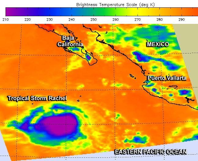
NASA's Aqua satellite passed over the large Tropical Storm Rachel on Sept. 25 at 4:41 p.m. EDT and saw colder cloud tops (purple) indicating thunderstorm heights were increasing and it was strengthening.
(Photo Credit: Image : NASA JPL, Ed Olsen)
NASA's Aqua satellite passed over the large Tropical Storm Rachel on Sept. 25 at 4:41 p.m. EDT and saw colder cloud tops (purple) indicating thunderstorm heights were increasing and it was strengthening.
(Photo Credit: Image : NASA JPL, Ed Olsen)
Rachel was moving toward the west-northwest near 14 mph (22 kph) and is expected to turn to the north-northwest late on Sept. 27.
The National Hurricane Center forecast calls for an increase in wind shear by Sept. 28 and beyond while Rachel moves over marginally cooler water and into a drier, more stable environment. So, steady weakening is expected to begin by on Sunday, Sept. 28, with the cyclone likely becoming a remnant low early next week.