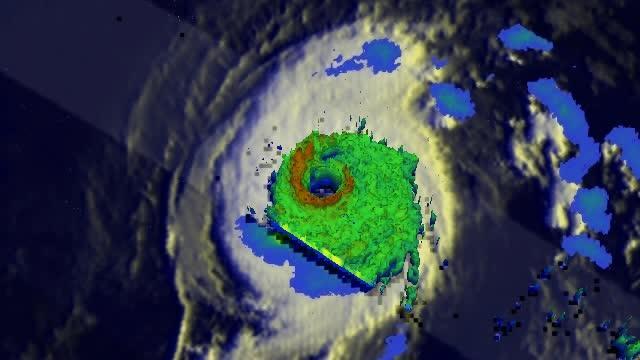
NASA's Tropical Rainfall Measuring Mission satellite known as TRMM flew directly over the eye of powerful Hurricane Iselle and found extremely heavy rainfall rates occurring there.
On August 4, 2014 at 1037 UTC (6:37 a.m. EDT) when TRMM passed over the storm, Iselle had winds of about 120 knots (about 138 mph) at that time making it a dangerous category four hurricane on the Saffir-Simpson hurricane wind scale. Rainfall from TRMM's Microwave Imager (TMI) and Precipitation Radar (PR) instruments was overlaid on an enhanced infrared image from NOAA's GOES-West satellite that showed cloud extent. The composite image showed the diameter of the storm and the rate in which rain was falling within it. The TRMM PR saw rain falling at a rate of almost 182 mm (about 7.2 inches) per hour in Iselle's eye wall.
TRMM data was also used to create a 3-D image of the storm to help forecasters see cloud heights. At NASA's Goddard Space Flight Center in Greenbelt, Maryland, a 3-D image was produced using radar reflectivity values from TRMM's Precipitation Radar (PR) instrument. The 3-D image showed storms in Iselle's eye wall reaching from 13km (8 miles) to the surface of the ocean below.
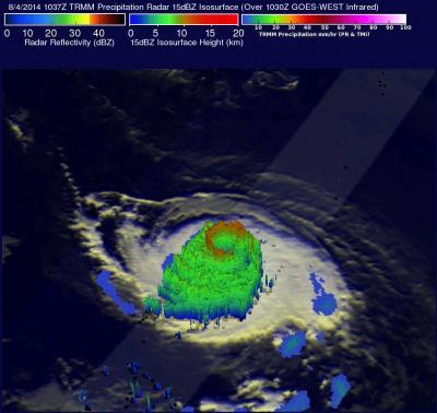
NASA's TRMM Satellite found storms in Iselle's eye wall reaching from 13km (8 miles) high and very heavy rain falling at a rate of almost 182 mm (about 7.2 inches) per hour in Iselle's eye wall.
(Photo Credit: Image : SSAI/NASA, Hal Pierce)
On August 4 at 19:40 UTC (3:40 p.m. EDT), the Moderate Resolution Imaging Spectroradiometer (MODIS) instrument aboard NASA's Terra satellite took a visible image of Hurricane Iselle that showed a clear, cloud-free eye. The visible image also showed a thick band of powerful thunderstorms circling the eye. The image was created by the MODIS Rapid Response Team at NASA Goddard.
On August 5, at 5 a.m. EDT (0900 UTC) the center of Hurricane Iselle was located near latitude 15.9 north and longitude 138.6 west. The National Hurricane Center (NHC) reported that Iselle's maximum sustained winds are near 125 mph (205 kph), making Iselle a category three hurricane on the Saffir-Simpson Hurricane wind scale. Further weakening is forecast during the next couple of days.
NHC noted that Iselle is moving toward the west near 8 mph (13 kph) and this general motion is expected to continue this morning. Iselle should turn toward the west-northwest at a faster forward speed later today and Wednesday, August 3. The estimated minimum central pressure is 955 millibars.
Hurricane Iselle is predicted by the National Hurricane Center (NHC) to weaken as it heads westward into the Central Pacific Ocean. Iselle is expected to move over the Big Island as a tropical storm late Thursday, August 5, 2014.

On August 4 at 19:40 UTC, the MODIS instrument aboard NASA's Terra satellite took this visible image of Hurricane Iselle in the Eastern Pacific Ocean.
(Photo Credit: Image : NASA Goddard MODIS Rapid Response Team)
NASA's TRMM Satellite found storms in Iselle's eye wall reaching from 13km (8 miles) high and very heavy rain falling at a rate of almost 182 mm (about 7.2 inches) per hour in Iselle's eye wall.
(Photo Credit: Image : SSAI/NASA, Hal Pierce)